I woke up this morning (around 6am) to the familiar pitter-patter of raindrops hitting last year’s oak leaves on the ground outside my house. The storm has begun!
In an effort to preempt difficulties of leaving Yosemite Valley due to possible flooding, the National Park Service put out a press release informing the public that Yosemite Valley would close to visitors at 5pm yesterday. All roads leading into the valley are closed, however certain areas of Yosemite are still open for visitors, such as Hetch Hetchy Dam and the Merced and Tuolumne Groves of Sequoias.
All but ‘essential’ employees are to be gone from the valley later today. I, along with two others, are remaining at The Ansel Adams Gallery as essential employees. I will be helping any efforts to minimize damage to buildings here, as well as maintain security. Gratefully, the president of the gallery installed a generator a few years ago for events like this – as a way to keep the gallery operating during the many power outages that occur in this outpost, far from generating stations. Although we are officially closed, the generator might come in handy for the three of us, should the power go out. Another concern with rising water is that the valley’s sewer pumping stations may have to be turned off to keep spilling of raw sewage to a bare minimum. Sewer and water are expected to be turned off. We could be living by bare-minimum means these next few days…perhaps longer!
All Eyes on The Gauge
As of this morning –
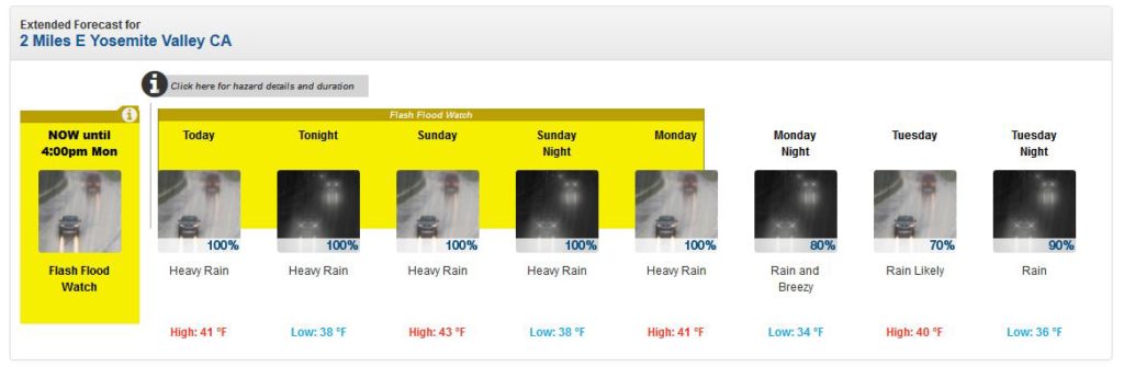
Here’s just a peek at what the National Weather Service predicts for the weather through Tuesday Night:
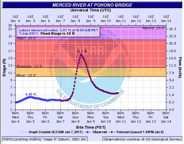
Here’s also NOAA’s predition of the water level of the Merced River at Pohono Bridge:
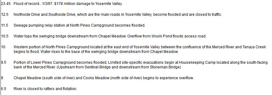
Lastly, here is a list of flood impacts (again by NOAA), measured in feet of water, to areas within Yosemite Valley:
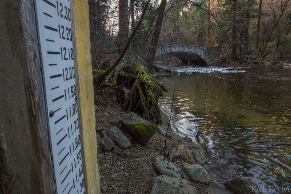
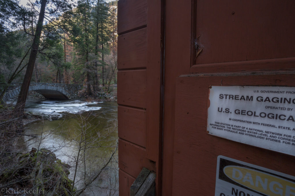
Yesterday, I got the idea that I should go down to the gauging station at Pohono Bridge and take some photos of the station that all eyes will be glued to in the next days as the Merced River begins to rise. Actually, I’ve never given the gauging station a second thought as I’ve driven passed it hundreds of times while entering the valley. EVERYONE must pass by it if you arrive to Yosemite Valley via Hwy’s 120 or 140, because you are forced to drive over Pohono Bridge – fairly menial at first glance, but still a beautiful arching stone bridge. The gauging station sits just upriver, on the south side of the river, from the bridge.
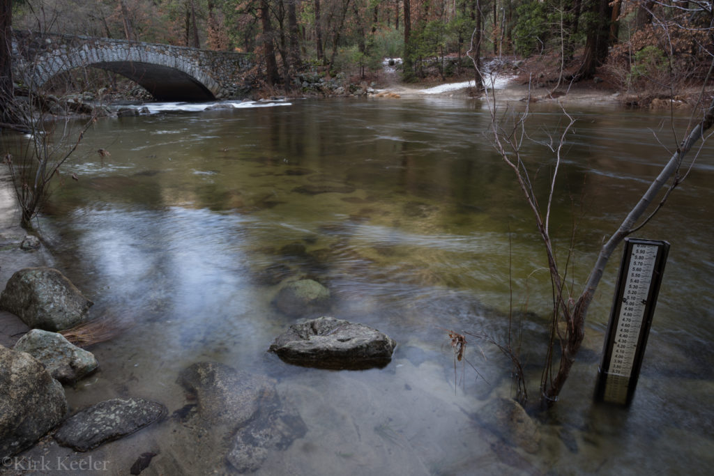
As I walked over to the gauge station, I immediately noticed the gauges on either side of the building, along with a small gauge in the river, right next to the station. Here are some pics I took yesterday, around 3pm.
Here’s the small gauge in the water. If you click on it, you’ll see the water level was just under 3.7 feet – a very harmless, calm Merced River yesterday:
This photo shows the gauge on the side of the station facing the river. Because of my height, I was only able to show the gauge up to 12.3 feet. 12.5 feet, as stated by the flood impacts image above, is the beginning of both roads, Northside and Southside Drive, being flooded.
This final image just shows that this building is indeed a ‘stream gauging’ station:
As I stood by this station, looking at the river level at under 3.7 feet yesterday, it was hard for me to fathom the river being 6 feet over my head for the beginning of flooding, much less the projected 16.1 feet the river might get to (over 10 feet above me!).
For now, all the remaining essential employees, myself included, will be waiting with anticipation as this winter rain storm unleashes the relentless pitter-patter of rain drops. It’s my hope that this storm is colder than what’s predicted, and that the majority of precipitation falls as snow in the backcountry, thus holding back much of the water and lowering the water level in the Merced.
I’ll check back in as things progress.
Kirk